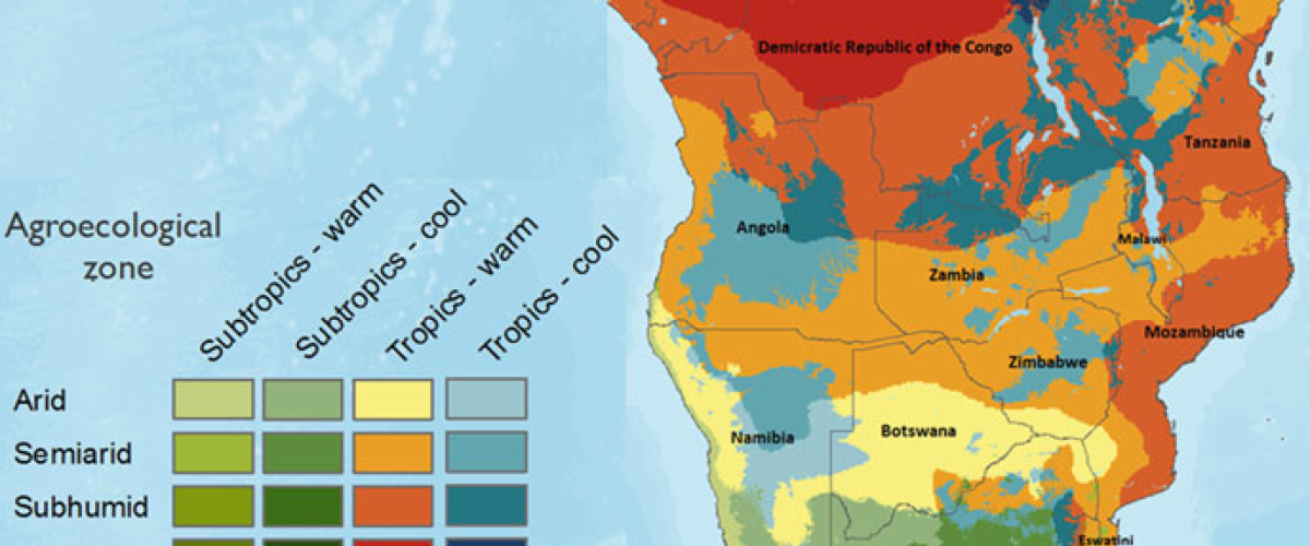
Across the vast landscapes of Southern Africa, agriculture has always been rooted in nature’s rhythms. Rainfall, soil texture, temperature, and terrain have long determined where crops grow best, which farming systems thrive, and how food is produced and sustained. These factors are traditionally captured through Agro-Ecological Zones (AEZs) — critical tools that guide planning, input application, land suitability assessments, and climate adaptation strategies.
But as the climate shifts, soils degrade, and agricultural systems evolve, so too must the frameworks that underpin them. The reality is sobering: many of Southern Africa’s AEZ maps are no longer fit for purpose. Developed decades ago using outdated methodologies and parameters, they are increasingly out of sync with current environmental and agricultural conditions.
It is in this context that a transformative regional agenda is taking shape — one that seeks to redefine agro-ecological zoning across the SADC region to align with modern realities and drive resilience in food systems.
The Turning Point: A Collective Regional Commitment
In March 2025, over 120 experts and stakeholders from 14 SADC Member States gathered in Johannesburg for a Consultative Workshop on Agro-Ecological Zoning and Soil Mapping. Convened by the Centre for Coordination of Agricultural Research and Development for Southern Africa (CCARDESA) through the World Bank-funded Food Systems Resilience Programme (FSRP), the workshop marked the beginning of a bold, regionally coordinated effort to update, harmonise, and operationalise AEZ systems.
The gathering was timely. Delegates presented detailed country reports, revealing a diverse array of AEZ frameworks — many rooted in the 1970s and 1980s, and few equipped to account for today’s complex dynamics. It became clear that while each country has developed its own zoning approach — based on rainfall, soil type, altitude, and temperature — the region as a whole lacks consistency, interoperability, and up-to-date data.
Crucially, the workshop catalysed consensus: the re-zoning of agro-ecological regions is not only necessary — it is urgent.
Evidence of Fragmentation and Need for Reform
The disparities across national AEZ frameworks are significant. Consider the following examples:
- Angola still references a zoning model developed in 1973, originally designed with 36 distinct zones, now consolidated into five rural regions.
- Zambia uses an AEZ classification dating back over 50 years, with minimal revision to reflect evolving climate conditions.
- Eswatini operates with both four-zone and six-zone models, depending on context, with no recent harmonisation.
- Mozambique’s last major update was in 2015, but even this lacks uniform methodology across institutions.
- Zimbabwe has recently undertaken significant reforms, updating its AEZs in 2020 and 2023 using modern tools such as GIS, remote sensing, and climate modelling. These reforms revealed notable shifts in agro-ecological boundaries, highlighting the impacts of climate change.
In most countries, soil maps remain outdated, inconsistent, or inaccessible, with a lack of digitisation and harmonised classification systems. Digital tools such as GIS and remote sensing are underutilised, and there is limited integration of socio-economic indicators that influence land use, input efficiency, and resilience outcomes.
This lack of standardisation has far-reaching implications: poorly aligned investment strategies, inefficient input use, reduced productivity, and a weakened ability to adapt to climate change.
 |  |
CCARDESA and the Soil Health and Fertilizer Hub: Coordinating a Regional Response
In recognition of the strategic importance of AEZ reform, the SADC Ministers responsible for Agriculture and Food Security, Fisheries and Aquaculture has appointed CCARDESA as the official host of the SADC Soil Health and Fertilizer Hub — a regional platform designed to address soil fertility, land use planning, and agro-ecological knowledge gaps.
The Hub — currently being operationalised with FSRP support — will serve as a centre of excellence for:
- Coordinating the harmonisation of AEZ methodologies across Member States;
- Providing technical guidance on digital soil mapping and classification;
- Promoting integrated land use planning that aligns with agro-ecological realities;
- Supporting the generation and sharing of data for policy and investment decision-making;
- Aligning soil and agro-ecological zoning efforts with fertiliser recommendations and climate-smart interventions.
Through this mandate, CCARDESA is positioned to drive a regional shift from fragmented, outdated systems to data-driven, harmonised, and future-oriented agro-ecological planning.
The Strategic Value of Re-Zoning
Re-zoning is not merely a scientific exercise. It is a strategic enabler of food systems resilience and agricultural transformation. Accurate and up-to-date AEZs provide a foundation for:
- Climate adaptation: Updated zones guide crop diversification, identify suitable locations for drought-tolerant or early-maturing varieties, and support regenerative practices.
- Efficient input use: Zoning enables more accurate fertiliser and water recommendations, reducing costs and environmental degradation.
- Targeted investments: Governments and development partners can better identify where to invest in irrigation, storage, extension services, and infrastructure.
- Early warning systems: AEZs can improve the accuracy of climate risk models, supporting proactive responses to drought, pests, and floods.
- Trade and regional planning: Harmonised zoning allows for better coordination of regional value chains, investment corridors, and cross-border agricultural initiatives.
In short, AEZs provide the spatial intelligence that underpins effective decision-making across the entire agricultural value chain.
From Dialogue to Implementation
The March 2025 workshop concluded with Member States agreeing to:
- Review and update national AEZ and soil maps;
- Mobilise national task forces and stakeholder consultations;
- Contribute to a regional harmonised AEZ framework to be coordinated by CCARDESA;
- Develop country-specific roadmaps with clearly defined targets, methodologies, and funding strategies.
A Regional Concept Note, currently under development, will consolidate these commitments into a unified programme of action. Through the SADC Soil Health and Fertilizer Hub, and with continued FSRP support, CCARDESA is actively coordinating this process — ensuring that the re-zoning agenda advances from dialogue to delivery.
A New Era for Agro-Ecological Intelligence
Southern Africa cannot afford to plan tomorrow’s agriculture using yesterday’s maps. The region faces complex challenges — from erratic rainfall and degraded soils to shifting crop viability and land use pressure. In this context, accurate and harmonised agro-ecological zoning is not a luxury; it is a necessity.
By investing in updated AEZ frameworks, supported by robust data and coordinated regional leadership, Southern Africa can reposition itself for sustainable agricultural growth and climate resilience. The work initiated in Johannesburg — and now championed by CCARDESA through the Soil Health and Fertilizer Hub — marks the beginning of a new era in land use planning and food systems transformation.
Images: SADC MAPP project document, ReseachGate and ScienceDirect.